Heritage

Giant Springs State Parks

Giant Springs State Park

Giant Springs State Park

Giant Springs State Park

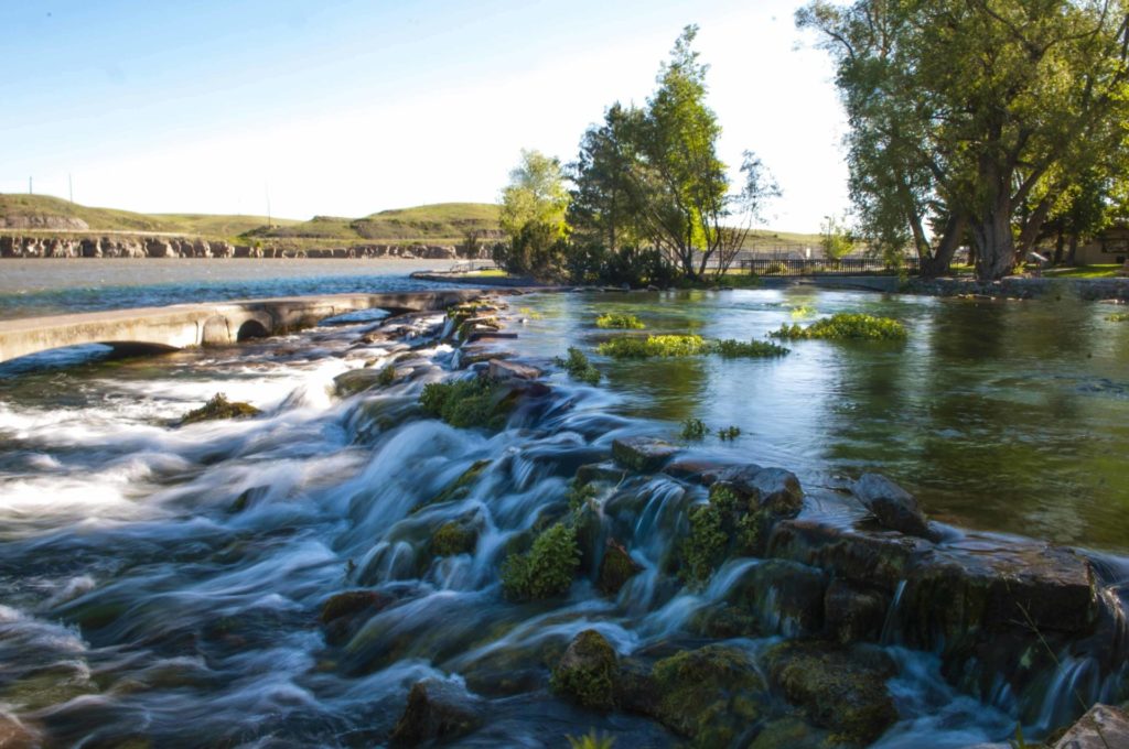
Located just outside of Great Falls lies Giant Springs State Park.

Originally discovered by Lewis & Clark in 1805, Giant Springs is one of the largest freshwater springs in the country.

Come marvel at this day-use park's remarkable features and view the variety of birdlife. Take part in their special events, picnic by the Missouri River, visit the fish hatchery and visitor center, walk along the Rivers Edge Trail, view the nearby Rainbow Falls overlook, or visit the neighboring Lewis and Clark Interpretive Center operated by the U.S. Forest Service.

Giant Springs State Park
IMG_5965

Download Campsite Map

IMG_5966

Download Park Map

Things to do:

The spring flows at a rate of 156 million gallons of water per day and is always 54 degrees Fahrenheit! Multiple bridges cross the crystal clear water that makes up Giant Springs, allowing visitors to peer in and see the growing vegetation and even an occasional fish!

While you won’t find any camping at Giant Springs State Park, you won’t find the park lacking in activities! The Roe River (also found in Giant Springs State Park) was once listed in the Guinness Book for World Records as the world’s shortest river!

  • Visit the fish hatchery and visitor center.
  • Take a walk on the Rivers Edge Trail.
  • Go on a hike along the many trails hugging the Missouri River.
  • Take in the Rainbow Falls at the overlook.
  • Visit the Lewis and Clark Interpretive Center, located nearby and operated by the U.S. Forest Service.

The water found in Giant Springs comes from the Madison Aquifer under the Little Belt Mountains. Because the water stays around 54 degrees year-round, Giant Springs State Park is great to visit regardless of the season!

In the winter, the steam rises off of the unfrozen water and birds flock around the warm water, while in the summer, the park is, on average, 20 degrees cooler than the nearby city of Great Falls.

Did You Know

Curious what other visitors have had to say about the park?

"Absolutley beautiful place top visit. Especially during spring and summer time. Trail access is easy from here and is a must see for anyone paying through or visiting."

"This is by far the best park in Great Falls and has a lot of good history posted around the park. There is a very clear natural spring, a playground for the kids, lots of barbecues and picnic areas. Just don't leave a mess like some of the tourists do.. throw your trash away and keep this place looking nice."

"Turned out to be a great Sunday to visit the park. Sun was shining, no wind, 38 degrees out but it felt great. Picnickers we're about. Nice "museum" for the hatchery. Got to feed some really big rainbow trout."

"This is a must see attraction if you visit Great Falls. The trout hatchery, the kids pond, the amazing views, and excellent fishing right from the park. We had our engagement photos done here as well. Bring a picnic lunch and spend the day."


Quick Facts
  • pine icon

    Park

    DAY USE ONLY
    Open all year
    Sunrise - Sunset

  • pine icon

    Location

    4803 Giant Springs Road Great Falls, MT 59405

Parks That Others Are Visiting

Giant Springs State Park Read More »

Fort Owen State Park

Fort Owen State Park

Fort Owen State Park

Travel 25 minutes south of Missoula, MT and into Stevensville, MT to Fort Owen State Park. Here you will find the remains of the oldest pioneer settlement in the State of Montana.

A beautiful place to visit, however, Fort Owen State Park is currently under major construction.

Fort Owen State Park
IMG_5965

Download Campsite Map

IMG_5966

Download Park Map

Wanting to visit?

Originally home to the first Catholic Church in Montana, founded by Father DeSmet in 1841, Fort Owen has a rich history and is listed in the National Register of Historic Places.

Here are some of our favorites when visiting Fort Owen State Park:

  • Check out the museum!
  • Capture the historical significance through photography!
  • Enjoy your picnic with amazing views.
  • Don’t forget your binoculars if you plan to do any wildlife and bird watching!
  • Visit the Lee Metcalf National Wildlife refuge just down the road.
  • Visit nearby Stevensville and the St. Mary’s Mission.
  • Plus so much more!

Fort Owen served as an important trading hub for Western Montana for over 20 years. However, when the Mullan Road was built in 1863, connecting Fort Benton to Walla Walla, Washington, it became the main transportation route and bypassed Fort Owen, going north through Missoula instead. This property has passed through many hands, one acre surrounding the remains of the fort was given to the Fort Owen Historical Association in 1937. In 1956 they conveyed it to the state of Montana for one dollar.

In addition to its many firsts, it also was the first recorded land transaction in Montana and contains the oldest constructed buildings in the State of Montana. Today you can tour one of the barracks that served as John Owen’s home and library, see the outline of the fort’s walls, a reconstructed root cellar, the well-house and a historic cabin. The rooms in the east barracks feature period furnishings and artifacts and visitors will find interpretive signs and exhibits which detail the region's history.

Did You Know

Curious what other visitors have had to say about the park?

"Wonderful Place. Every One Must Go."

"Nice historical monument. Nicely kept."

"What a neat little place full of Montana history. We stopped in to see Fort Owen State Park while we were in the Stevensville area visiting. It’s not a big place so you won’t spend much time here. There are some good lessons in history walking through the buildings."

"Lots of information. Great for families. Lots of information without over doing it. Informative and fun."


Quick Facts
  • pine icon

    Park

    March 1 - October 31:   9 a.m. - 6 p.m. daily

    November 1 - February 28:  Closed for the Winter

  • pine icon

    Location

    99 Fort Owen Ranch Rd Stevensville, MT 59870

Parks That Others Are Visiting

Fort Owen State Park Read More »

First Peoples Buffalo Jump State Park

First Peoples Buffalo Jump State Park

First Peoples Buffalo Jump State Park

Located South of Great Falls and just outside of Ulm, First Peoples Buffalo Jump is one of the largest buffalo jumps in the United States and is known in the archeology community as the most significant buffalo jump in the world! Evidence suggests that this site, also known as the Ulm Pishkin, may have been the most frequently used buffalo jump in the world.

First Peoples Buffalo Jump State Park
IMG_5966

Download Park Map

Park history

A 6,000 square foot Visitor Center helps to pay homage to both the buffalo and the Native American’s who honor it. Inside you’ll find buffalo culture exhibits, a circle for storytelling, a classroom, a gallery, and a bookstore!

Outside the Visitor Center are an outdoor amphitheater and even a few traditional games playing fields. The cliffsides now offer up amazing views to visitors from all over the world.

At the base of the cliff, you can see 18 feet of compact buffalo remains, but it can be difficult to make out distinct items like skulls or other bones after so many years. The original name of the park “Ulm Pishkin” comes from the Blackfeet word "Pis'kun," meaning "deep kettle of blood”. The mile-long cliff ranges from 30 to 50 feet in height, any higher and meat may have been damaged and unusable. Of the over 300 buffalo kill sites in Montana, First Peoples Buffalo Jump is one of only three that are protected.

Native tribes would stampede herds of bison off the cliff and collect the remains below. Bison meat served as a main staple in the early Native American diets of the region. While this form of hunting was very popular and safe compared to the alternatives it was not the most common.

Ambush killing, where the hunters would sneak up to the animal before attacking, was the most frequent way for them to provide food, tools, and clothing to their families. It was very dangerous due to the size and strength of the animal. Because of this many of these sites are considered sacred. Ambush hunting became less and less utilized as the horse came onto the scene, allowing hunters to keep pace with the bison and guide them more effectively to sites like this and eventually as they began breeding horses even the buffalo jump became obsolete. Giving way to mounted hunters who could chase, kill, and carry back the precious remains.

The most accepted theory as to the use of “Buffalo Jumps” has the hunters slowly encircling the herds and pushing them towards the area. It could take hours if not days and was very dangerous.

As the herds would draw closer and closer to the cliffs they would be guided to a specific spot by others using low fences made of twisted vines and large rocks. These “Drive Lines” can still be found today. They sometimes extended over a quarter of a mile away.

Once the Buffalo had reached their holding spot the hunters would approach, sometimes wearing wolf pelts and sneaking on all fours, and when the time was right they would jump up shouting and making loud noises creating a stampede.

The fastest and bravest of the hunters, called “Buffalo-Runners” would dance in front of the herds leading them over the cliff. Often jumping to a safe spot just below the ledge.

After the herd had gone over or dispersed the women, children, and elders would move through the aftermath killing any that may have survived and then processing and harvesting as much of the animal as possible.

Plan to spend at least two hours at First Peoples Buffalo Jump to make time for the many activities!

*Notice!: Due to recent world-wide events Visitors Centers, Regional Offices, Ranger Stations, Campgrounds, and other facilities including many restrooms are now closed to the public. MT FWP is monitoring the situation and making changes to their policy on a rolling two week basis.

Years after the area was settled it became a cattle ranch and eventually mining area. Eventually, in the 1950s the bone itself began to be mined before a local rancher named Earl Monroe leased the land to protect it from further destruction.

Earl kept the land off-limits to the public while under his care. The land went through many hands and many legal battles over the years before finally coming under the protection of the state in the late ‘90s and becoming a full-fledged state park in the year 2000.


Did You Know

Curious what other visitors have had to say about the park?

"The museum itself was extremely neat and clean. It's a small establishment that you can tour yourself - which I LOVED! The 2 guides were helpful and answered any questions that we had regarding the jump. I would absolutely suggest this place to anyone visiting the Great Falls area."

"What a piece of history we knew nothing about. Fascinating and then taking the drive to the cliffs I couldn't imagine running ahead of a herd of buffalo and at the last minute jumping over the edge to safety. This park is definitely worth a visit. Make the time."

"Great history and amazing views of the valley. A great 1 mile hike up to the buffalo jump cliff, or take the road around the other side of you don't want to hike it. Restroom is available in the visitors building and near the cliff."

"What a great place to see. It is so peaceful and tranquil. I enjoyed it so very much."


Quick Facts
  • pine icon

    Park

    Summer - open daily.
    Winter - open Wednesday through Sunday.

  • pine icon

    Summer Hours 

    April 12 - September 12: open 8 am - 6 pm daily.

  • pine icon

    Winter Hours

    Sept. 14 to March 31:
    10 am - 4 pm Wed - Sat and 12 pm - 4 pm Sun.
    Closed Monday and Tuesday.
    The gates at the top of the Jump may be closed during times of deep snow.

  • pine icon

    Location

    342 Ulm -Vaughn Rd. Ulm, MT 59485

First Peoples Buffalo Jump State Park Read More »

Elkhorn State Park 3

Elkhorn State Park

Elkhorn State Park

Elkhorn State Park

Traveling along gravel secondary roads outside of Boulder, you’ll find the once thriving town of Elkhorn, now one of the smallest state parks in the state.


Elkhorn State Park
IMG_5966

Download Park Map

These roads take you through a 19th-century mining landscape before you reach historic Fraternity Hall and Gillian Hall nestled within the privately-owned town of Elkhorn. Bring your camera to record these two picturesque structures from the late 1800's silver-mining ghost town, preserved as outstanding examples of frontier architecture. Each has been recorded in the Historic American Buildings Survey.

Three-quarters of a mile up the main road that runs through town (just outside of the state park property) lies the town cemetery where visitors can see the tombstone of Swiss miner Peter Wys who originally discovered the silver veins in the Elkhorn Mine!

Rich with mineral deposits (including silver), the Boulder Batholith originally drew settlers to the area and led to the establishment of Elkhorn in 1868, now a silver-mining ghost town. The 1880s and 1890s were the most populous times for Elkhorn, drawing around 2,500 residents at its peak, but after the Silver Crash of 1893, the town saw a drop of 75 percent of its population in just two months. In total, the Elkhorn Mine yielded about $14 million in silver.

Did You Know

Curious what other visitors have had to say about the park?

"Beautiful Town! Really neat old ghost town and mining artifacts. There are only a few buildings you can go into, but lots of history around town! The wood water tower has be repaired. I highly recommend checking out the cemetery, pretty sad story. Plenty of parking all over."

"Ghost town with sad cemetary interesting ghost town with private homes located around the buildings. There are two buildings in restored condition and other buildings scattered throughout untouched. Went further afield to the cemetery located on the hillside. Sad, unkempt and scattered tombs and plaques tell the story of the deaths of children during an epidemic."

"Lots of interesting old Stone and wood buildings give you a taste of the town that must have been grand. Check out the historic and protected Fraternity Hall. Be sure to walk up the hill to the cemetery. Monuments range from grand to crumbling wooden markers. Especially poignant are the many, many graves of children who died in the 1888-9 diphtheria epidemic."

"It still remains as one of the most well-preserved buildings in the town. Later, Elkhorn's prosperity wanted as the demand for silver decreased. When railroad service to Elkhorn was halted, most of the inhabitants left. Today, Elkhorn is a Montana State Park."


Quick Facts
  • pine icon

    Park

    Open Year-Round, Pack-In/Pack-Out

  • pine icon

    Location

    812 Elkhorn Street Elkhorn, MT

Elkhorn State Park Read More »

Clark's Lookout State Park 4

Clark’s Lookout State Park

Clark's Lookout State Park

Clark’s Lookout State Park

Clark's Lookout State Park is located one mile north of Dillon, above the Beaverhead River.

Established December 23, 1985, Clark's Lookout is set along the historic Lewis and Clark trail.

Clark's Lookout State Park
IMG_5966

Download Park Map

Looking to camp?

On August 13, 1805, Lewis & Clark and the Corps of Discovery found what is now Clark’s Lookout State Park. Having traveled from the headwaters of the Missouri River and up the Jefferson River to continue their search for a passage to the Pacific Ocean, they found an incredible view instead.

The view from the top of the hill provided Lewis & Clark and the Corps of Discovery with a view of what lay ahead. And William Clark worked to explore and document the hill overlooking the Beaverhead River.

  • Take a walk to the monument and gaze out over the land once surveyed by William Clark.
  • Have a picnic at the perfectly located picnic area.
  • Take a hike through the rest of the 7.23 acres via hiking trails with interpretive signs.
  • Cultural and Heritage information is provided on-site.
  • Check out all of the local wildlife, including bird watching.
  • Photographic opportunities abound.
  • Plus so many more!

Interpretive signs help to explain the navigational methods used by the Corps of Discovery.

A short hike to the top of the lookout provides an incredible view of the Beaverhead Valley.

You’ll also find a granite monument shaped like a compass which displays the three compass readings Clark took in 1805! The compass monument’s design came from a small pocket compass Clark carried during the expedition!

Did You Know

Curious what other visitors have had to say about the park?

"Fun! I love history. Didn't know this was there until we drove by."

"Great place to stop for a walk and see a historic sight."

"Picturesque views."

"Nice place to stop for a short walk up a path to some beautiful views."


Quick Facts
  • pine icon

    Park

    Open:  May 1 - September 30

    Hours:  8:00 a.m. - Sunset

  • pine icon

    Location

    25 Clark’s Lookout Road
    Dillon, MT 59725 Park

Parks That Others Are Visiting

Clark’s Lookout State Park Read More »

Chief Plenty Coups State Park

Chief Plenty Coups State Park

Chief Plenty Coups State Park

Chief Plenty Coups State Park is named for the last traditional chief of the Crow Nation, Chief Plenty Coups (Aleek-chea-ahoosh, meaning "many achievements"). Plenty Coups was a man of war - and then a man of peace - whose vision has helped bridge a gap between two cultures.

Recognized for his bravery and leadership, he was made chief of the Apsáalooke (Crow) tribe by age 28. 

We are able to bring you valuable information about this amazing state park thanks to the support of:

Chief Plenty Coups State Park
IMG_5966

Download Park Map

Looking to camp?

On his land, Chief Plenty Coups built a log home, began farming, and eventually opened a general store.

You won’t find camping at Chief Plenty Coups State Park, but you will find a day’s worth of activities!

  • Hike the ¾ mile trail around the grounds and near the creek.
  • Take in the beauty and serenity while enjoying lunch in the picnic area.
  • Bird watching.
  • Learn more about Chief Plenty Coups’ life and Native American culture at the visitor center.
  • Have a fishing license? Try and catch a fish in the creek!

While traveling to Washington D.C., Plenty Coups toured George Washington's estate, Mount Vernon, and was struck by the idea of a national monument open to all.

In 1932, at age 84, Chief Plenty Coups passed away and at his and his wife, Strikes the Iron’s, request, a portion of their homestead was made into a state park which eventually grew to 195 acres for all people to visit and learn from and still operates as such today!

At the burial of the unknown soldier at Arlington Cemetery in 1921, Chief Plenty Coups attended as a representative of all the Indian Nations. While the ceremony commenced, Chief Plenty Coups placed his headdress and two coups sticks on the tomb in honor of the fallen soldiers.

The headdress and coups sticks can still be seen today on display in the Virginia cemetery. Chief Plenty Coups was a well-known statesman and ambassador, he knew several U.S. Presidents and met many foreign leaders during his life. 

Chief Plenty Coups is remembered for helping to bridge the divide between Native American people and white settlers during a time when the Native American people were being coerced into giving up their traditional ways. 

Through the Indian Allotment Act, Chief Plenty Coups received an allotment of land which included a sacred spring, something that Plenty Coups envisioned as a young man, and became one of the first Apsáalooke to own and settle on a farm.

Did You Know

Curious what other visitors have had to say about the park?

"We stopped to eat lunch here. Peaceful place to be. Well taken care of and a lot of pride goes into it."

"Helpful and friendly rangers. Nice historic buildings. Good walking. Beautiful surroundings. Natural spring."

"Friendly museum worker and very informative info about the Chief and his tribe. Nice and easy scenic walk around the grounds."

"It was our first time here and it was truly an emotional experience. So much history to read and the photo books to look through were amazing!! Definitely recommend!"


Quick Facts
  • pine icon

    Park

    Day Use Only. No Camping.

    Summer Hours

    mid-May – mid-September

    Open daily 8 am - 8 pm

    Winter Hours

    Wed-Sunday 8:00am to 5:00pm

    Closed Monday and Tuesday

  • pine icon

    Visitor Center & Chief’s House

    10 am - 5 pm.

    Closed all federal and state holidays except Memorial Day, Fourth of July, and Labor Day. Park is also closed December 24th and 31st.

  • pine icon

    Location

    1 Edgar/Pryor Road

    Pryor, MT 59066

Parks That Others Are Visiting

Chief Plenty Coups State Park Read More »

Beaverhead Rock Hero

Beaverhead Rock State Park

Beaverhead Rock State Park

Beaverhead Rock State Park

Beaverhead Rock can be viewed and photographed from a distance, but cannot be directly accessed.

There are two great locations to best see the rock formation, though. The first is 14 miles south of Twin Bridges on Highway 41 where a pull-off has informational signs and an interesting bird sculpture.

The second location is from another Montana State Park, Clark’s Lookout State Park in Dillon.

Beaverhead Rock, also known as Point of Rocks, is a rock formation overlooking the Beaverhead River and is on the National Register of Historic Places.


Beaverhead Rock State Park
IMG_5966

Download Park Map

Sacagawea, a young Shoshone Indian guide traveling with the Lewis and Clark Expedition in 1805, recognized this rock formation and knew that she may be in the vicinity of her relatives. The sighting gave the expedition hope that they may be able to find Native peoples from which to acquire horses for their trip across the mountains to the Pacific Ocean.

Meriwether Lewis, August 8, 1805 wrote: "The Indian woman recognized the point of a high plain to our right which she informed us was not very distant from the summer retreat of her nation on a river beyond the mountains which runs to the west. This hill she says her nation calls the beaver's head from a conceived resemblance of its figure to the head of that animal. She assures us that we shall either find her people on this river or on the river immediately west of its source; which from its present size cannot be very distant."

Did You Know

Curious what other visitors have had to say about the park?

"It is relatively unchanged since Lewis and Clark described it, in spite of attempts to do so"

"Beautiful wetlands and good fishing nearby!"

"So much fun and it's pretty."

"Beautiful!"


Quick Facts
  • pine icon

    Park

    Open Year-Round

  • pine icon

    Location

    62 Beaverhead Rock Road Twin Bridges, MT 59754

Beaverhead Rock State Park Read More »

Bannack State Park 2

Bannack State Park

Bannack State Park

Bannack State Park

Bannack State Park is the location of Montana's first major gold discovery, founded in 1862 this historic ghost town still has over 50 standing buildings!

Find out more about the history of the park down below.

Bannack State Park
IMG_5965

Download Campsite Map

Tours are conducted from the visitor center, which is open from Memorial Day through Labor Day. Bannack Days, with historic displays, re-enactors, and activities, are held the 3rd weekend annually in July (Bannack days has been cancelled for 2020).

The campground has 28 sites, including a rental tipi located along Grasshopper Creek, a hike-in/bike-in campsite, with four tent pads, and a group picnic site.

Bannack State Park is a National Historic Landmark and the site of Montana's first major gold discovery on July 28, 1862. This strike set off a massive gold rush that swelled Bannack's population to over 3,000 by 1863.

As the value of gold steadily dwindled, Bannack's bustling population was slowly lost. Over 50 buildings line Main Street; their historic log and frame structures recall Montana's formative years.

Did You Know

Curious what other visitors have had to say about the park?

"This was a great Ghost town. So many buildings to explore and go into. Well worth the drive and a day trip."

"Very interesting!! Crazy these buildings are still standing. Would have paid for a guided tour to explain everything."

"One of the best ghost towns I've been to. Most buildings are open and you can go in them."

"Didn't find any ghosts, but had a great, informative evening tour. Fun, well-preserved town with interesting stories of the wild west and life in a gold boom town. And when it gets dark, the starry sky is mesmerizing."


Designation

"Bannack is a beautiful area that holds so much Montana history. I always find it fascinating to see how people lived in that era, how much we take for granted, and just how tough and hardy they had to be back then."

Quick Facts
  • pine icon

    Park

    Open all year.

    Summer Hours:
    Memorial Day - August 10, 2022
    8 am - 9 pm

    Shoulder Season Hours:
    August 11, 2022 - September 30, 2022
    8 a.m. - Sunset

    Winter Hours:
    Oct 1, 2022 - Memorial Day 2023
    8 am - 5 pm
    Closed December 24 & 25

  • pine icon

    Campground

    Open all year.

  • pine icon

    Potable Water

    Available summer season.

  • pine icon

    Visitor Center

    Open Memorial Day - Labor Day
    10 am - 6 pm

  • pine icon

    Location

    721 Bannack Rd Dillon, MT

Parks That Others Are Visiting

Bannack State Park Read More »

Anaconda Smelter Stack State Park 1

Anaconda Smoke Stack State Park

Anaconda Smoke Stack State Park

Anaconda Smoke Stack State Park

Anaconda Smoke Stack State Park is located off of I-90, 24 miles from Butte, MT.

Situated on top on a hillside of the Anaconda Pintler Mountain Range foothills, you can see this state park from miles around.

As a monument to the nation's period of industrialism, particularly when viewed in conjunction with Butte’s Berkely Pit, it immortalizes the scale of the mining that once dominated and influenced this part of Montana.

Anaconda Smelter Stack State Park
IMG_5964

Download Brochure

IMG_5966

Download Park Map

Listed in the National Register of Historic Places, the smelter closed in 1980.  In 1983, the stack, the smelter, and the other buildings nearby were listed as a Superfund cleanup site.  Efforts to clean up contaminated soils, structures, and other mine debris began in the 1980s and are ongoing.  In order to protect the public and limit their liability, the Atlantic Richfield Company closed the area around the stack and public visitation is allowed only during officially organized tours or events.

Much like the smelter and other buildings that used to be located on Smelter Hill nearby, the smokestack was likely to be demolished as part of the Superfund cleanup efforts.  A group of longtime Anaconda residents formed the "Anacondans To Preserve The Stack" committee.  Their efforts led to the preservation of the big stack and they continue to work to find ways to preserve the stack and make it accessible to the public.  Today visitors can view and photograph the stack from a distance.

Interpretive signs describing the history of the stack are located in the viewing site near Goodman Park. 

Montana Public Radio produced a great story about the Anaconda Smoke Stack for its 100th anniversary in August of 2018.  You can listen to and read that story here.

The Anaconda Smoke Stack is taller than the Washington Monument by 30 feet. In fact, the Washington Monument would easily fit inside this smokestack.

Did You Know

Curious what other visitors have had to say about the park?

"Cool town to drive through. Tower is visible for miles from Highway..so we had to check it out on drive back through."

"Worth the stop. Very well done."

"Nicely done. Very interesting, worth a look and reading about the stack."

"Great History of Anaconda and Butte when Mining was heavy in this area, Learned a lot more than I knew. Definitely worth visiting Anaconda area."


Designation

"The very essence of what the town of Anaconda was and is! Great interpretive signs and a mock circumference of the stack showing you just how big it really is! Must see"

Quick Facts
  • Tree icon

    Park

    Open daily all year
    Daylight hours

  • Tree icon

    Location

    100 Anaconda Smelter Rd, Anaconda, MT 59711, United States

Parks That Others Are Visiting

Anaconda Smoke Stack State Park Read More »

Skip to content