Day-Use Only

Clark's Lookout State Park 4

Clark’s Lookout State Park

Clark's Lookout State Park

Clark’s Lookout State Park

Clark's Lookout State Park is located one mile north of Dillon, above the Beaverhead River.

Established December 23, 1985, Clark's Lookout is set along the historic Lewis and Clark trail.

Clark's Lookout State Park
IMG_5966

Download Park Map

Looking to camp?

On August 13, 1805, Lewis & Clark and the Corps of Discovery found what is now Clark’s Lookout State Park. Having traveled from the headwaters of the Missouri River and up the Jefferson River to continue their search for a passage to the Pacific Ocean, they found an incredible view instead.

The view from the top of the hill provided Lewis & Clark and the Corps of Discovery with a view of what lay ahead. And William Clark worked to explore and document the hill overlooking the Beaverhead River.

  • Take a walk to the monument and gaze out over the land once surveyed by William Clark.
  • Have a picnic at the perfectly located picnic area.
  • Take a hike through the rest of the 7.23 acres via hiking trails with interpretive signs.
  • Cultural and Heritage information is provided on-site.
  • Check out all of the local wildlife, including bird watching.
  • Photographic opportunities abound.
  • Plus so many more!

Interpretive signs help to explain the navigational methods used by the Corps of Discovery.

A short hike to the top of the lookout provides an incredible view of the Beaverhead Valley.

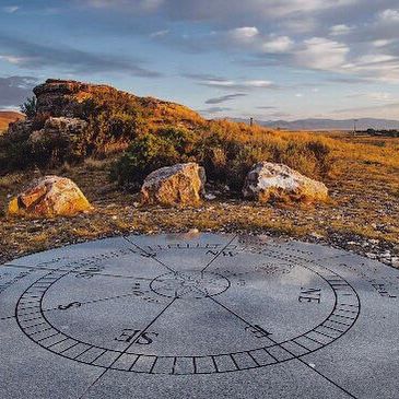
You’ll also find a granite monument shaped like a compass which displays the three compass readings Clark took in 1805! The compass monument’s design came from a small pocket compass Clark carried during the expedition!

Did You Know

Curious what other visitors have had to say about the park?

"Fun! I love history. Didn't know this was there until we drove by."

"Great place to stop for a walk and see a historic sight."

"Picturesque views."

"Nice place to stop for a short walk up a path to some beautiful views."


Quick Facts
  • pine icon

    Park

    Open:  May 1 - September 30

    Hours:  8:00 a.m. - Sunset

  • pine icon

    Location

    25 Clark’s Lookout Road
    Dillon, MT 59725 Park

Parks That Others Are Visiting

Clark’s Lookout State Park Read More »

Chief Plenty Coups State Park

Chief Plenty Coups State Park

Chief Plenty Coups State Park

Chief Plenty Coups State Park is named for the last traditional chief of the Crow Nation, Chief Plenty Coups (Aleek-chea-ahoosh, meaning "many achievements"). Plenty Coups was a man of war - and then a man of peace - whose vision has helped bridge a gap between two cultures.

Recognized for his bravery and leadership, he was made chief of the Apsáalooke (Crow) tribe by age 28. 

We are able to bring you valuable information about this amazing state park thanks to the support of:

Chief Plenty Coups State Park
IMG_5966

Download Park Map

Looking to camp?

On his land, Chief Plenty Coups built a log home, began farming, and eventually opened a general store.

You won’t find camping at Chief Plenty Coups State Park, but you will find a day’s worth of activities!

  • Hike the ¾ mile trail around the grounds and near the creek.
  • Take in the beauty and serenity while enjoying lunch in the picnic area.
  • Bird watching.
  • Learn more about Chief Plenty Coups’ life and Native American culture at the visitor center.
  • Have a fishing license? Try and catch a fish in the creek!

While traveling to Washington D.C., Plenty Coups toured George Washington's estate, Mount Vernon, and was struck by the idea of a national monument open to all.

In 1932, at age 84, Chief Plenty Coups passed away and at his and his wife, Strikes the Iron’s, request, a portion of their homestead was made into a state park which eventually grew to 195 acres for all people to visit and learn from and still operates as such today!

At the burial of the unknown soldier at Arlington Cemetery in 1921, Chief Plenty Coups attended as a representative of all the Indian Nations. While the ceremony commenced, Chief Plenty Coups placed his headdress and two coups sticks on the tomb in honor of the fallen soldiers.

The headdress and coups sticks can still be seen today on display in the Virginia cemetery. Chief Plenty Coups was a well-known statesman and ambassador, he knew several U.S. Presidents and met many foreign leaders during his life. 

Chief Plenty Coups is remembered for helping to bridge the divide between Native American people and white settlers during a time when the Native American people were being coerced into giving up their traditional ways. 

Through the Indian Allotment Act, Chief Plenty Coups received an allotment of land which included a sacred spring, something that Plenty Coups envisioned as a young man, and became one of the first Apsáalooke to own and settle on a farm.

Did You Know

Curious what other visitors have had to say about the park?

"We stopped to eat lunch here. Peaceful place to be. Well taken care of and a lot of pride goes into it."

"Helpful and friendly rangers. Nice historic buildings. Good walking. Beautiful surroundings. Natural spring."

"Friendly museum worker and very informative info about the Chief and his tribe. Nice and easy scenic walk around the grounds."

"It was our first time here and it was truly an emotional experience. So much history to read and the photo books to look through were amazing!! Definitely recommend!"


Quick Facts
  • pine icon

    Park

    Day Use Only. No Camping.

    Summer Hours

    mid-May – mid-September

    Open daily 8 am - 8 pm

    Winter Hours

    Wed-Sunday 8:00am to 5:00pm

    Closed Monday and Tuesday

  • pine icon

    Visitor Center & Chief’s House

    10 am - 5 pm.

    Closed all federal and state holidays except Memorial Day, Fourth of July, and Labor Day. Park is also closed December 24th and 31st.

  • pine icon

    Location

    1 Edgar/Pryor Road

    Pryor, MT 59066

Parks That Others Are Visiting

Chief Plenty Coups State Park Read More »

Beaverhead Rock Hero

Beaverhead Rock State Park

Beaverhead Rock State Park

Beaverhead Rock State Park

Beaverhead Rock can be viewed and photographed from a distance, but cannot be directly accessed.

There are two great locations to best see the rock formation, though. The first is 14 miles south of Twin Bridges on Highway 41 where a pull-off has informational signs and an interesting bird sculpture.

The second location is from another Montana State Park, Clark’s Lookout State Park in Dillon.

Beaverhead Rock, also known as Point of Rocks, is a rock formation overlooking the Beaverhead River and is on the National Register of Historic Places.


Beaverhead Rock State Park
IMG_5966

Download Park Map

Sacagawea, a young Shoshone Indian guide traveling with the Lewis and Clark Expedition in 1805, recognized this rock formation and knew that she may be in the vicinity of her relatives. The sighting gave the expedition hope that they may be able to find Native peoples from which to acquire horses for their trip across the mountains to the Pacific Ocean.

Meriwether Lewis, August 8, 1805 wrote: "The Indian woman recognized the point of a high plain to our right which she informed us was not very distant from the summer retreat of her nation on a river beyond the mountains which runs to the west. This hill she says her nation calls the beaver's head from a conceived resemblance of its figure to the head of that animal. She assures us that we shall either find her people on this river or on the river immediately west of its source; which from its present size cannot be very distant."

Did You Know

Curious what other visitors have had to say about the park?

"It is relatively unchanged since Lewis and Clark described it, in spite of attempts to do so"

"Beautiful wetlands and good fishing nearby!"

"So much fun and it's pretty."

"Beautiful!"


Quick Facts
  • pine icon

    Park

    Open Year-Round

  • pine icon

    Location

    62 Beaverhead Rock Road Twin Bridges, MT 59754

Beaverhead Rock State Park Read More »

Bannack State Park 2

Bannack State Park

Bannack State Park

Bannack State Park

Bannack State Park is the location of Montana's first major gold discovery, founded in 1862 this historic ghost town still has over 50 standing buildings!

Find out more about the history of the park down below.

Bannack State Park
IMG_5965

Download Campsite Map

Tours are conducted from the visitor center, which is open from Memorial Day through Labor Day. Bannack Days, with historic displays, re-enactors, and activities, are held the 3rd weekend annually in July (Bannack days has been cancelled for 2020).

The campground has 28 sites, including a rental tipi located along Grasshopper Creek, a hike-in/bike-in campsite, with four tent pads, and a group picnic site.

Bannack State Park is a National Historic Landmark and the site of Montana's first major gold discovery on July 28, 1862. This strike set off a massive gold rush that swelled Bannack's population to over 3,000 by 1863.

As the value of gold steadily dwindled, Bannack's bustling population was slowly lost. Over 50 buildings line Main Street; their historic log and frame structures recall Montana's formative years.

Did You Know

Curious what other visitors have had to say about the park?

"This was a great Ghost town. So many buildings to explore and go into. Well worth the drive and a day trip."

"Very interesting!! Crazy these buildings are still standing. Would have paid for a guided tour to explain everything."

"One of the best ghost towns I've been to. Most buildings are open and you can go in them."

"Didn't find any ghosts, but had a great, informative evening tour. Fun, well-preserved town with interesting stories of the wild west and life in a gold boom town. And when it gets dark, the starry sky is mesmerizing."


Designation

"Bannack is a beautiful area that holds so much Montana history. I always find it fascinating to see how people lived in that era, how much we take for granted, and just how tough and hardy they had to be back then."

Quick Facts
  • pine icon

    Park

    Open all year.

    Summer Hours:
    Memorial Day - August 10, 2022
    8 am - 9 pm

    Shoulder Season Hours:
    August 11, 2022 - September 30, 2022
    8 a.m. - Sunset

    Winter Hours:
    Oct 1, 2022 - Memorial Day 2023
    8 am - 5 pm
    Closed December 24 & 25

  • pine icon

    Campground

    Open all year.

  • pine icon

    Potable Water

    Available summer season.

  • pine icon

    Visitor Center

    Open Memorial Day - Labor Day
    10 am - 6 pm

  • pine icon

    Location

    721 Bannack Rd Dillon, MT

Parks That Others Are Visiting

Bannack State Park Read More »

Anaconda Smelter Stack State Park 1

Anaconda Smoke Stack State Park

Anaconda Smoke Stack State Park

Anaconda Smoke Stack State Park

Anaconda Smoke Stack State Park is located off of I-90, 24 miles from Butte, MT.

Situated on top on a hillside of the Anaconda Pintler Mountain Range foothills, you can see this state park from miles around.

As a monument to the nation's period of industrialism, particularly when viewed in conjunction with Butte’s Berkely Pit, it immortalizes the scale of the mining that once dominated and influenced this part of Montana.

Anaconda Smelter Stack State Park
IMG_5964

Download Brochure

IMG_5966

Download Park Map

Listed in the National Register of Historic Places, the smelter closed in 1980.  In 1983, the stack, the smelter, and the other buildings nearby were listed as a Superfund cleanup site.  Efforts to clean up contaminated soils, structures, and other mine debris began in the 1980s and are ongoing.  In order to protect the public and limit their liability, the Atlantic Richfield Company closed the area around the stack and public visitation is allowed only during officially organized tours or events.

Much like the smelter and other buildings that used to be located on Smelter Hill nearby, the smokestack was likely to be demolished as part of the Superfund cleanup efforts.  A group of longtime Anaconda residents formed the "Anacondans To Preserve The Stack" committee.  Their efforts led to the preservation of the big stack and they continue to work to find ways to preserve the stack and make it accessible to the public.  Today visitors can view and photograph the stack from a distance.

Interpretive signs describing the history of the stack are located in the viewing site near Goodman Park. 

Montana Public Radio produced a great story about the Anaconda Smoke Stack for its 100th anniversary in August of 2018.  You can listen to and read that story here.

The Anaconda Smoke Stack is taller than the Washington Monument by 30 feet. In fact, the Washington Monument would easily fit inside this smokestack.

Did You Know

Curious what other visitors have had to say about the park?

"Cool town to drive through. Tower is visible for miles from Highway..so we had to check it out on drive back through."

"Worth the stop. Very well done."

"Nicely done. Very interesting, worth a look and reading about the stack."

"Great History of Anaconda and Butte when Mining was heavy in this area, Learned a lot more than I knew. Definitely worth visiting Anaconda area."


Designation

"The very essence of what the town of Anaconda was and is! Great interpretive signs and a mock circumference of the stack showing you just how big it really is! Must see"

Quick Facts
  • Tree icon

    Park

    Open daily all year
    Daylight hours

  • Tree icon

    Location

    100 Anaconda Smelter Rd, Anaconda, MT 59711, United States

Parks That Others Are Visiting

Anaconda Smoke Stack State Park Read More »

Skip to content