Hunting

Maria’s River State Park

Marias River State Park

Marias River State Park

To get to there from I-15, take exit 358 and head east on Marias Valley Road North for 3.5 miles. Then turn west on Hjartarson Road and travel for 10.2 miles, then turn south for 2.5 miles.

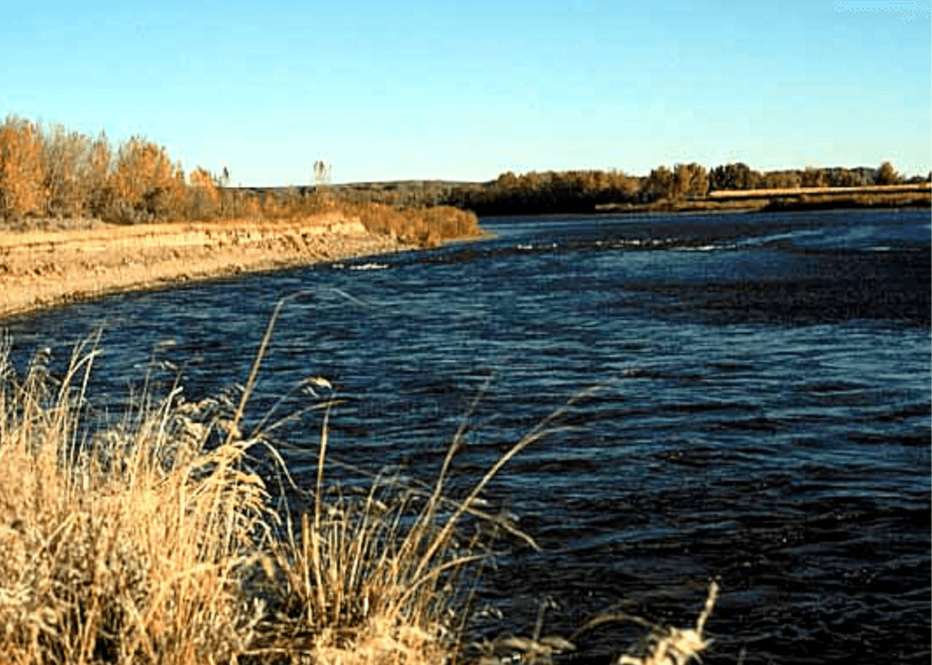
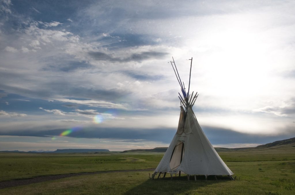
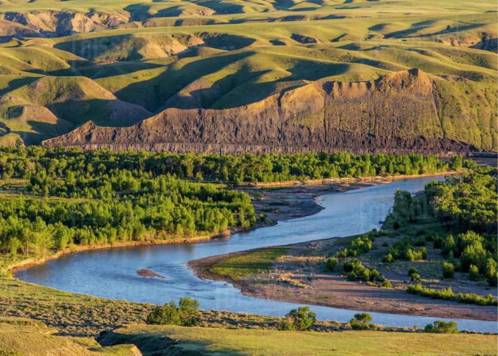
This 5,845-acre property, a combination of state park, and wildlife management area was established May 1, 2009. The site includes an undeveloped 14-mile stretch of the Marias River, as well as sagebrush, grassland, and short grass prairie habitats in the uplands.

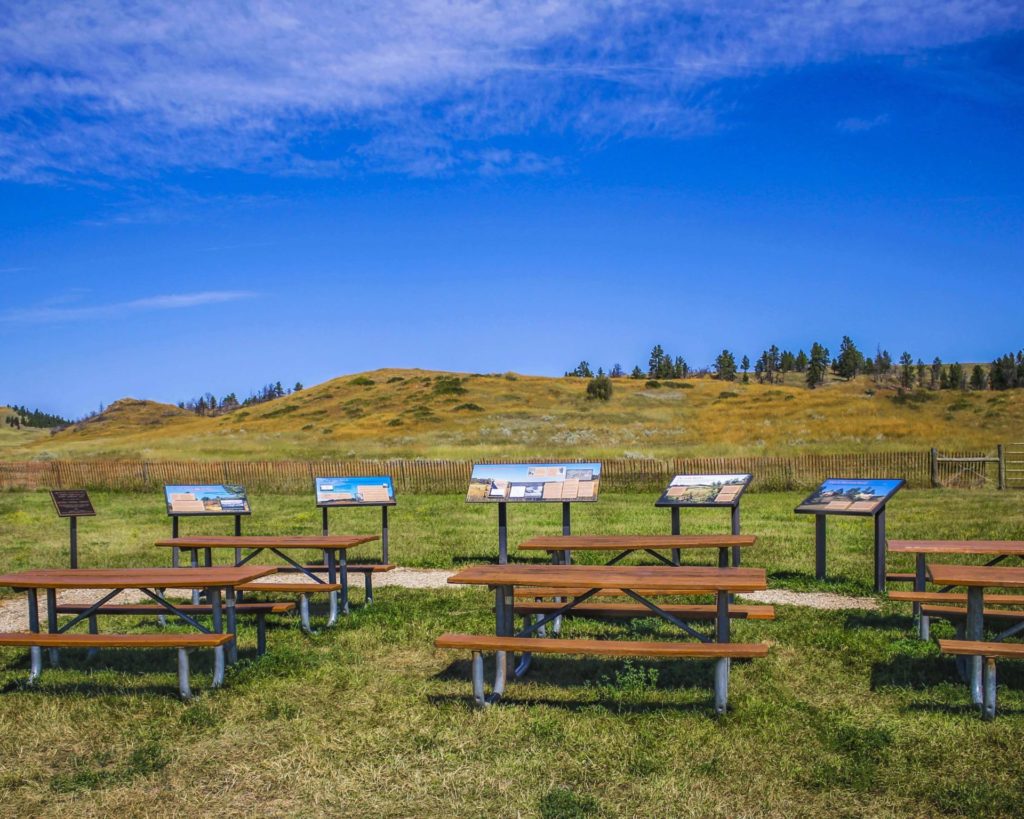
Non-motorized access only. Respect private property, do not trespass. Rules prevent discharge of weapons except for lawful hunting during established hunting seasons. Pack it in and pack it out. No facilities are offered at this time.

Marias River State Park

Park Activities

Park Features

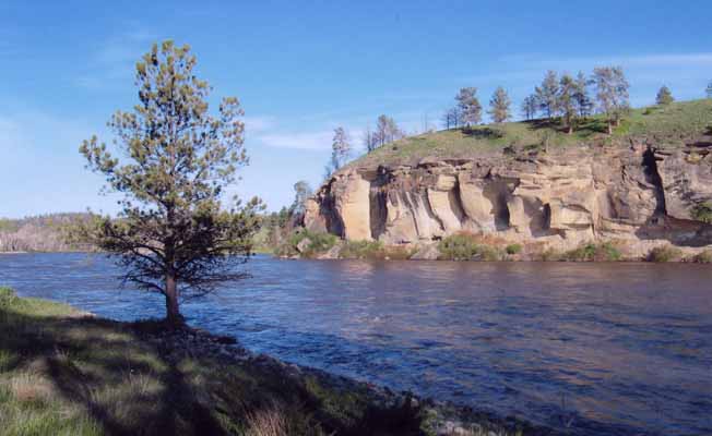
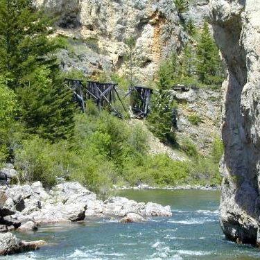
The Marias River flows through the Wildlife Management Area for 13 miles.

When FWP bought the land, officials believed an existing road on the east side of the WMA would provide access to the river and interior of the state park. However, an adjacent landowner disputed FWP plans and stated that the road was not public.

The landowner and FWP went through a formal mediation process, and FWP proposed transferring approximately 483 acres of the WMA to the landowner in exchange for public recreational access on Lincoln Road. In November 2015, the Fish and Wildlife Commission voted down the road proposal, leaving the State Park and Wildlife Management Area without vehicle access to the river.

Montana Fish, Wildlife and Parks purchased the 5,485-acre Wildlife Management Area in 2008. A 1,878-acre state park sits next to it.

The land was previously owned by Charlie Lincoln and known as the Lincoln Ranch. When Lincoln died, he left his ranch to the Catholic Diocese of Montana with instructions to give FWP the first right of refusal if the diocese decided to sell the land.

FWP paid $2 million for the state park portion of the land, funded through a one-time appropriation from the 2007 Legislature, and $5.6 million for the WMA portion thanks to Habitat Montana funding.

The Marias River is void of any technical whitewater. It's an easy float, even for someone with minimal experience.

It provides an easy two-date float.

Did You Know

Curious what other visitors have had to say about the park?

"Beautiful, spacious, peaceful and fun!"

"It's beautiful here & I heard the fishing is good."

"The only state park in the middle of MT. Nice cottonwoods surround good size lake. Camp spots on the far side are more private and shaded in the afternoon. Beautiful prairie views."


"It is a fun place to hang out for the weekend. Great for fishing year-round."


Quick Facts
  • pine icon

    Park

    Open
    Apr 1 to Jan 15

  • pine icon

    Location

    From I-15, Exit 358 east to Marias Valley Road, North 3.5 miles, turn west on Hjartarson Road, for 10.2 miles, then south 2.5 miles.

Maria’s River State Park Read More »

Yellowstone River

Yellowstone River State Park

Yellowstone River State Park

Yellowstone River State Park

Yellowstone River State Park is just over 200 acres of what used to be the Circle R Ranch, which was purchased by FWP in 2008. Sandstone bluffs, pasturelands, and groves of cottonwood trees surround this unique park.

Unlike many state parks across Montana, you won't find many amenities or visitor information kiosks. This undeveloped park is adjacent to Wildlife Management Areas and BLM property, which allows users to experience solitude and quiet only miles from Montana's largest city, Billings.

Yellowstone River State Park

Looking for things to do?

There are many opportunities for recreation along the Yellowstone River.

Gravel along the river from Custer to Sidney often yields Montana agates (inquire locally or through the Custer Country tourism region for guide services or rockhounding tips).

Fishing and floating are two other favorite activities on the Yellowstone. Badlands scenery is abundant in Terry or Makoshika State Park (in Glendive, MT), where you can drive to view impressive rock formations.

The site contains 3,976 deeded acres and includes 5 miles of wooded Yellowstone River shoreline. The acquisition also secured for the public use of 5,450 acres of Bureau of Land Management (BLM) and state land that had been difficult to access.

Currently undeveloped, the park provides an ideal spot for hiking the day away. Sandstone bluffs overlook the Yellowstone River while deep canyons and ponderosa pine-lined coulees dot the landscape.

The area provides habitat for mourning doves, meadowlarks, mallards, Canada geese, wild turkeys, pheasants, sage grouse, sharptailed grouse, Hungarian partridge, mule deer, whitetail deer, pronghorn antelope, and even an occasional elk.

The Yellowstone is the last free-flowing river in the lower 48 states. From its headwaters in Lake Yellowstone downstream 670 miles to the Missouri River in North Dakota, the Yellowstone River flows as it has for centuries, in its natural state, undammed and untamed.

Clear, cool, swift and challenging it offers fishermen and river runners some of the best water Montana has to offer.

To fishermen, its blue-ribbon waters are known world round for an abundance of big trout. As it flows through Montana, the big river goes through many changes - from steep-walled canyons where boulders churn its green waters to the eastern part of the state where the river broadens to take a lazy path through fertile farm country.

There are many opportunities for recreation along the Yellowstone River.


Did You Know

Curious what other visitors have had to say about the park?

"Beautiful, spacious, peaceful and fun!"

"It's beautiful here & I heard the fishing is good."

"The only state park in the middle of MT. Nice cottonwoods surround good size lake. Camp spots on the far side are more private and shaded in the afternoon. Beautiful prairie views."


"It is a fun place to hang out for the weekend. Great for fishing year-round."


Quick Facts
  • pine icon

    Park

    Open Year-Round

  • pine icon

    Location

    989 Ackley Lake Road Hobson, MT 59452

Yellowstone River State Park Read More »

Sluice Boxes State Park

Sluice Boxes State Park

Sluice Boxes State Park

Sluice Boxes State Park was created in 1974 and included significant historic structures and remnants of the abandoned towns of Riceville and Albright that once existed for the purpose of mining limestone in the canyon.

Belt Creek which formed the canyon that is the centerpiece of the park, has long been popular for outdoor recreation. Citizens of nearby Great Falls began visiting the area for fishing, camping, hunting and other activities as early as 1889 when the railroad connecting silver mines in the Barker and Hughesville mining districts to smelters in Great Falls was completed.

Sluice Boxes State Park
IMG_5965

Download Campsite Map

IMG_5966

Download Park Map

Things to do:

The park is now popular with local visitors, history enthusiasts, fishermen, hikers, and others. The rugged landscape creates dramatic scenery as it contrasts distinctly with the rolling hills and rounded mountains of this part of central Montana.

A walk down the old railroad grade trail will bring you to fishing access, floating, swimming and wildlife viewing. Be aware: steep cliffs, rugged terrain and cold, swift water can pose a risk to visitors, so be sure to take caution!

If you’re looking to camp, you’ll need a Backcountry Campsite Permit. You can contact Montana Fish, Wildlife and Parks headquarters in Great Falls to do so.

The Barker Mines and the Montana Central Railroad are part of the history of Sluice Boxes State Park.
Carved by Belt Creek as it comes down from the Little Belt Mountains, the large limestone cliffs and steep ledges are the signatures of Belt Creek Canyon.

By September of 1890, the Central Montana Railroad dropped off fisherman at various locations along Belt Creek in what is now Sluice Boxes State Park. When Belt Creek was named a blue ribbon trout stream in the 1920s, the railroad ran special “fishing trains” on Sundays.

This area was once home to prospectors searching for precious metals, miners, muleskinners, smelter men and railroaders building bridges. Today, visitors can find the remnants of mines, cabins and a railroad along the banks of Belt Creek in the park.

Did You Know

Curious what other visitors have had to say about the park?

"We stop every trip because the view is gorgeous no matter what the season."

"Beautiful place. Be prepared if you plan on hiking the trail. Lots of river crossings."

"A great place to hike if you don't mind crossing the river several times. It is best to go in the late summer when the river is at its lowest point so that you can cross safely. There is an old homestead to explore as well."

"Family & pet friendly hike. Beautiful for pictures and swimming. There is a spot where you can do a cliff jump into the lake."


Quick Facts
  • pine icon

    Park

    Open all year
    Parking area/ trailhead open sunrise to sunset.

  • pine icon

    Campground

    Backcountry open 24/7

    Permit required

  • pine icon

    Location

    38 Evans Riceville Road Belt, MT 59412

Sluice Boxes State Park Read More »

Rosebud Battlefield State Park 6

Rosebud Battlefield State Park

Rosebud Battlefield State Park

Rosebud Battlefield State Park

The location of the Battle of Rosebud, is an incredible and historical location that shouldn’t be missed!


Rosebud Battlefield State Park
IMG_5965

Download Campsite Map

The Park History

One of the largest battles of the Indian Wars, the Battle of Rosebud, or “Where the Girl Saved Her Brother” as referred to by the Northern Cheyenne, lasted for eight hours. Because Crook’s troops had been withdrawn from the war zone in order to resupply, they were not there to support Colonel Custer at the Battle of the Little Bighorn one week later.

The battlefield is still used throughout the year by U.S. Armed Forces to study military strategy, including how troops take on an enemy who is familiar with the landscape.

The park includes Kobold Buffalo Jump, a cliff once used by Native Americans and marked with petroglyphs. A short hike within the gap to the cliffs will allow you to see these.

The use of metal detectors, digging and the collecting or removal of artifacts is restricted and bikes are allowed on existing roadways only. Be very cautious while in the park as rattlesnakes reside in the area!

Although camping isn’t available at Rosebud Battlefield, there is camping available at Tongue River Reservoir State Park only 13 miles south.

Rosebud Battlefield is one of the most undeveloped, pristine battlefields in the nation. While looking for the Sioux and Northern Cheyenne villages of Chief Sitting Bull, Brigadier General George Cook, along with 1000 troops and Crow and Shoshone scouts, were unprepared for an organized attack.

On June 17, 1876, an equal or greater number of warriors led by Sioux Chief Crazy Horse and Cheyenne Chiefs Two Moon, Young Two Moons, and Spotted Wolf, attacked the band of soldiers.

Did You Know

Curious what other visitors have had to say about the park?

"What a unique piece of Montana history! The story of the young Cheyenne woman saving her brother against the US Army happened here."

"Great experience. Largest battle in the Indian wars. Very interesting presentation."

"This is the battle that preceded the battle of little big horn by a few days and would have saved Custer if it did not happen. A must see!"

"This is part of our western history few people know of. It was over looked becsuse of Custers actions eight days later."


Quick Facts
  • pine icon

    Park

    Open all year/Day Use Only

  • pine icon

    Location

    42 HC Busby, MT 59016

Rosebud Battlefield State Park Read More »

Pirogue-Island-State-Park

Pirogue Island State Park

Pirogue Island State Park

Pirogue Island State Park

Pirogue Island State Park just a mile north of Miles City, Montana, a little more than two hours from Billings, Montana by way of Interstate 94, and on the north side of a bend in the Yellowstone River.

In addition to extensive hiking, birding, and wildlife viewing, the island is a possible site where the Corps of Discovery and Capt. Clark camped in 1806 on the return voyage of their famous expedition.

We are able to bring you valuable information about this amazing state park thanks to the support of:

Visit Southeast Montana
Pirogue Island Email
IMG_5965

Download Campsite Map

IMG_5966

Download Park Map

Looking to hike?

For visitors who enjoy hiking, Pirogue Island features 2.8 miles of designated hiking trails with interpretive signs offering insights on the history and wildlife of the island. Looking for more than 2.8 miles? You’re in luck!

As a very level site, visitors will find an easy walk throughout the 269 acres and when the water isn’t flowing, visitors can take a walk along the tree-shaded side channels and wade through the pools of water that form during hot weather.

The island boasts prominent plant life with more than 140 species of plants including a healthy population of cottonwood trees, peach-leaf willow, green ash, and red-osier dogwood.

An isolated, cottonwood-covered island located on the Yellowstone River, Pirogue Island State Park is an excellent location for enjoying the natural beauty of Montana. While wading through channels of the Yellowstone River is the most popular way to get to Pirogue Island, others stop by as they float down the river.

Pirogue Island State Park is 500 miles from where the Yellowstone River begins south of Yellowstone National Park and 170 miles from where it ends near Williston, North Dakota.

Did You Know

Curious what other visitors have had to say about the park?

"Growing up in this area I never discovered this until I went back and visited. There is a great trail (about 6 miles) that takes you all around the park and next to the river."

"Good spot for hunting and fishing"

"I love the walking trail and having the chance to see wildlife."

"Great place to view"


Quick Facts
  • pine icon

    Park

    Day use only

    Open year-round, 7 am to 10 pm.

    Mid-August to early April is the best time to cross the channel and reach the island.

  • pine icon

    Location

    Miles City, MT 59301

    Travel north on 59N to the Kinsey Rd/Hwy 489.
    Turn right and follow for 2 miles to the turnoff for Pirogue Island State Park.
    Parking and amenities are at the end of the road.

Pirogue Island State Park Read More »

Makoshika

Makoshika State Park

Makoshika State Park

Makoshika State Park

Makoshika State Park features spectacular badland formations and the remains of the infamous Tyrannosaurus Rex, as well as other amazing dino fossils.

We are able to bring you valuable information about this amazing state park thanks to the support of:

Visit Southeast Montana
Makoshika State Park
IMG_5965

Download Campsite Map

IMG_5966

Download Park Map

Looking to dig for fossils?

The park offers special events throughout the year, including Montana Shakespeare in the Park, Friday night campfire programs and youth programs in summer, and the famous Buzzard Day festival, the second Saturday in June, featuring 10k & 5k races and a fun run, Native American singers & drummers, jumping house, food, disc golf tournament, hikes and more!

Visitors are asked not to bring metal detectors, and no digging, collecting or removal of artifacts is allowed.

Included within the park are an archery site, scenic drives, hiking trails, 28 camping sites, a group picnic area, and an outdoor amphitheater.

The visitor center at the park entrance has interpretive exhibits that are great for kids.

Did You Know

Curious what other visitors have had to say about the park?

"Really cool rock features. Very easy hikes to see amazing views."

"Never a disappointment. I LOVE Makoshika park. I always stop by to visit the ranger's in the gift shop. They are all so very welcoming."

"The scenic overlooks are awesome. Some of the trails are slightly treacherous. Bring water on your walks. The staff are friendly and helpful. The visitor center has some very cool displays of the archeological finds from the area."

"We loved this park. Great views and hiking- decent privacy for spots even though there aren’t really trees to separate the sites. Lots of things to do nearby since it’s so close to town! Wish we had time to take a longer visit and hike more of the trails! Watch out for cacti!"


Quick Facts
  • pine icon

    Park

    Open daily 7:00 a.m. to 10:00 p.m.
    Water available year round

  • pine icon

    Campground 

    Open year round

  • pine icon

    Visitor Center

    Summer Hours

    May 1 – September 30
    Open daily 9:00 a.m. - 5:00 p.m.

    Winter Hours

    October 1 - April 30
    Open Wednesday - Sunday, 10:00 a.m. - 4:00 p.m.
    Closed all federal and state holidays except Memorial Day, Fourth of July, and Labor Day.

  • pine icon

    Location

    1301 Snyder Avenue Glendive, MT 59330

Makoshika State Park Read More »

Lewis & Clark Caverns State Park 1

Lewis & Clark Caverns State Park

Lewis & Clark Caverns State Park

Lewis & Clark Caverns State Park

Located just east of Whitehall, MT, lies the Lewis and Clark Caverns. Discovered in 1892 by local hunters, these caverns went on to become Montana's first state park.

As one of the largest known limestone cavern systems in the northwest, Montanans have been exploring the caves for over 100 years!

Lewis & Clark Caverns State Park
IMG_5965

Download Campsite Map

IMG_5966

Download Park Map

Interested in tours?

Access to the cave is by guided tours only, May through September, with limited candlelight tours offered in December. Lewis & Clark Caverns State Park also features camping and a network of trails to hike or bike, a state-of-the-art visitor center, interpretive displays, a gift shop, food and beverage concessions, an amphitheater, and interpretive events presented during the summer months.

Looking to camp?

The park has a large campground with 40 campsites, a tipi, and three cabins, which you can reserve online, and a group camping area, which you must contact the park to reserve. There is a $5 charge to use the dump station.

The site encompasses 3,015 acres. The entry area is at an elevation of 4,300 feet and the caverns area is at an elevation of 5,300 feet.

Cave access is only available through the guided tour. You will be asked to please wear a mask. 

Cavern Tours are now being offered. 

The park offers two tours: The Classic Tour, which visits the majority of the developed cave but is physically challenging, and The Paradise tour, that will guide you to the largest, most decorated rooms of the cave. Tour length is approximately 1 mile and the tour takes about 1 1/2 hours.

The tours are first come, first served.

Tickets are limited.

Get in touch with the park for more information. 

Bring a face covering. Face coverings are required during cave tours.

Although optional for other areas of the park. Park disinfecting procedures involve using a bleach solution.

Visitors should consider wearing new or very clean gloves, especially in the caverns where the handrails are cleaned with a bleach solution every tour.

Because of group size restrictions, tours are very limited. Park facilities that are open now are disinfected intermittently. We suggest visitors bring hand sanitizer and/or disinfecting wipes for personal use.

Lewis & Clark Caverns State Park features one of the largest known limestone caverns in the Northwest.

Did You Know

Curious what other visitors have had to say about the park?

"The caverns are amazing and the tours are fantastic. I have been through several times over the years and always loved the experience. The candlelight tours in the winter are amazing for the experience and historic aspects, but the summer tours really show off the caverns with the lights. All of the guides are passionate about their jobs and the caves, and love to teach. Great place to visit and bring friends and family."

"Absolutely beautiful! The bats are very cool to see as well! Can't wait to see it again."

"These Caverns are a jewel. The drive to the caverns winds along the Jefferson River, with cliffs adorning the sides of the road. Our party were excited to to the Caverns today, as it was the rare tour through the cave system with candles!!! This Candlelight tour is offered only at Christmas. What a treat!! The vision of the fellow participants weaving among the cave features is idyllic. It is surprising how much light the candlelight can make in the total dark. This is a best kept secret. The tour guides are top notch."

"A truly fascinating and unique experience! Amazing formations of nature. A true treasure. Outstanding tour and educational experience. Highly recommend!"


Quick Facts
  • pine icon

    Park

    Open Year-Round

  • pine icon

    Visitor Center

    May through September: 9 a.m. - 4:30 p.m. daily

    October through April: 10 a.m. - 4 p.m. daily

  • pine icon

    Water

    Available May through September as weather allows

  • pine icon

    Showers & Comfort Station

    Open through September as weather allows

  • pine icon

    Montana Gift Corral

    8:30 a.m. - 5 p.m. Wednesday through Monday

  • pine icon

    Location

    25 Lewis and Clark Caverns Rd. Whitehall, MT 59759

Lewis & Clark Caverns State Park Read More »

Fish Creek State Park 1

Fish Creek State Park

Fish Creek State Park

Fish Creek State Park

Fish Creek State Park is located at 851 Rivulet Road in Alberton.

Fish Creek State Park provides a large landscape State Park in western Montana with a diverse array of recreational opportunities such as hiking, mountain biking, angling, sightseeing, wildlife viewing, motorized use on open roads, and hunting.

Click Here To Access a Map!

Looking to camp?

From the lookout atop Williams Peak to the crystal clear blue pools of Fish Creek, this 5,603-acre state park is full of wildlife, beautiful scenery and places to explore.

The Alberton Gorge, with class 3-4 whitewater rafting, is nearby.

This undeveloped park lacks many amenities that other nearby parks feature such as a visitor center, camping facilities, or regular staffing

The 41,000 acres was acquired by the Nature Conservancy and Trust for Public Lands from the Plum Creek Timber Co. for $17 million. In 2010 the state of Montana officially gained ownership of the land, setting aside a share for the state park.

The topography of the park varies and includes timbered draws, ridges, flat stretches, riparian areas, and steep, narrow canyons.

There are around 60 miles of old logging roads within the park! As one of Montana’s newest state parks, there aren’t many amenities, but you will find plenty of activities! 

You won’t find camping at Fish Creek, yet, but if you’re feeling adventurous, the Alberton Gorge provides first-rate whitewater rafting. You may be looking for something a bit tamer though, in which case fishing is one of the most popular activities at Fish Creek State Park!

Many visitors love to hike up to the Williams Peak lookout which provides incredible views of the Mission Mountains to the northeast and Bitterroot Mountains to the southwest. 

Did You Know

Curious what other visitors have had to say about the park?

"Lots of forested lands. A new park, my first experience was cross country skiing."

"Great boon- docking spot. Lots of wildlife and views."

Quick Facts
  • pine icon

    Park

    Open Year-Round

  • pine icon

    Location

    851 Rivulet Road Alberton, MT 59820

Parks That Others Are Visiting

Fish Creek State Park Read More »

First Peoples Buffalo Jump State Park

First Peoples Buffalo Jump State Park

First Peoples Buffalo Jump State Park

Located South of Great Falls and just outside of Ulm, First Peoples Buffalo Jump is one of the largest buffalo jumps in the United States and is known in the archeology community as the most significant buffalo jump in the world! Evidence suggests that this site, also known as the Ulm Pishkin, may have been the most frequently used buffalo jump in the world.

First Peoples Buffalo Jump State Park
IMG_5966

Download Park Map

Park history

A 6,000 square foot Visitor Center helps to pay homage to both the buffalo and the Native American’s who honor it. Inside you’ll find buffalo culture exhibits, a circle for storytelling, a classroom, a gallery, and a bookstore!

Outside the Visitor Center are an outdoor amphitheater and even a few traditional games playing fields. The cliffsides now offer up amazing views to visitors from all over the world.

At the base of the cliff, you can see 18 feet of compact buffalo remains, but it can be difficult to make out distinct items like skulls or other bones after so many years. The original name of the park “Ulm Pishkin” comes from the Blackfeet word "Pis'kun," meaning "deep kettle of blood”. The mile-long cliff ranges from 30 to 50 feet in height, any higher and meat may have been damaged and unusable. Of the over 300 buffalo kill sites in Montana, First Peoples Buffalo Jump is one of only three that are protected.

Native tribes would stampede herds of bison off the cliff and collect the remains below. Bison meat served as a main staple in the early Native American diets of the region. While this form of hunting was very popular and safe compared to the alternatives it was not the most common.

Ambush killing, where the hunters would sneak up to the animal before attacking, was the most frequent way for them to provide food, tools, and clothing to their families. It was very dangerous due to the size and strength of the animal. Because of this many of these sites are considered sacred. Ambush hunting became less and less utilized as the horse came onto the scene, allowing hunters to keep pace with the bison and guide them more effectively to sites like this and eventually as they began breeding horses even the buffalo jump became obsolete. Giving way to mounted hunters who could chase, kill, and carry back the precious remains.

The most accepted theory as to the use of “Buffalo Jumps” has the hunters slowly encircling the herds and pushing them towards the area. It could take hours if not days and was very dangerous.

As the herds would draw closer and closer to the cliffs they would be guided to a specific spot by others using low fences made of twisted vines and large rocks. These “Drive Lines” can still be found today. They sometimes extended over a quarter of a mile away.

Once the Buffalo had reached their holding spot the hunters would approach, sometimes wearing wolf pelts and sneaking on all fours, and when the time was right they would jump up shouting and making loud noises creating a stampede.

The fastest and bravest of the hunters, called “Buffalo-Runners” would dance in front of the herds leading them over the cliff. Often jumping to a safe spot just below the ledge.

After the herd had gone over or dispersed the women, children, and elders would move through the aftermath killing any that may have survived and then processing and harvesting as much of the animal as possible.

Plan to spend at least two hours at First Peoples Buffalo Jump to make time for the many activities!

*Notice!: Due to recent world-wide events Visitors Centers, Regional Offices, Ranger Stations, Campgrounds, and other facilities including many restrooms are now closed to the public. MT FWP is monitoring the situation and making changes to their policy on a rolling two week basis.

Years after the area was settled it became a cattle ranch and eventually mining area. Eventually, in the 1950s the bone itself began to be mined before a local rancher named Earl Monroe leased the land to protect it from further destruction.

Earl kept the land off-limits to the public while under his care. The land went through many hands and many legal battles over the years before finally coming under the protection of the state in the late ‘90s and becoming a full-fledged state park in the year 2000.


Did You Know

Curious what other visitors have had to say about the park?

"The museum itself was extremely neat and clean. It's a small establishment that you can tour yourself - which I LOVED! The 2 guides were helpful and answered any questions that we had regarding the jump. I would absolutely suggest this place to anyone visiting the Great Falls area."

"What a piece of history we knew nothing about. Fascinating and then taking the drive to the cliffs I couldn't imagine running ahead of a herd of buffalo and at the last minute jumping over the edge to safety. This park is definitely worth a visit. Make the time."

"Great history and amazing views of the valley. A great 1 mile hike up to the buffalo jump cliff, or take the road around the other side of you don't want to hike it. Restroom is available in the visitors building and near the cliff."

"What a great place to see. It is so peaceful and tranquil. I enjoyed it so very much."


Quick Facts
  • pine icon

    Park

    Summer - open daily.
    Winter - open Wednesday through Sunday.

  • pine icon

    Summer Hours 

    April 12 - September 12: open 8 am - 6 pm daily.

  • pine icon

    Winter Hours

    Sept. 14 to March 31:
    10 am - 4 pm Wed - Sat and 12 pm - 4 pm Sun.
    Closed Monday and Tuesday.
    The gates at the top of the Jump may be closed during times of deep snow.

  • pine icon

    Location

    342 Ulm -Vaughn Rd. Ulm, MT 59485

First Peoples Buffalo Jump State Park Read More »

Skip to content